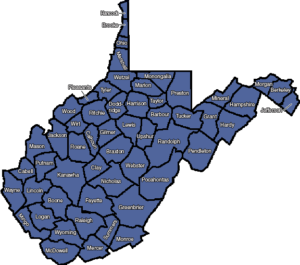
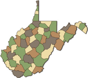
West Virginia County Quizzes
West Virginia Studies
<< Here are the topics on this page; Click to jump/scroll down >>
“Introduction” – West Virginia County Quiz Page
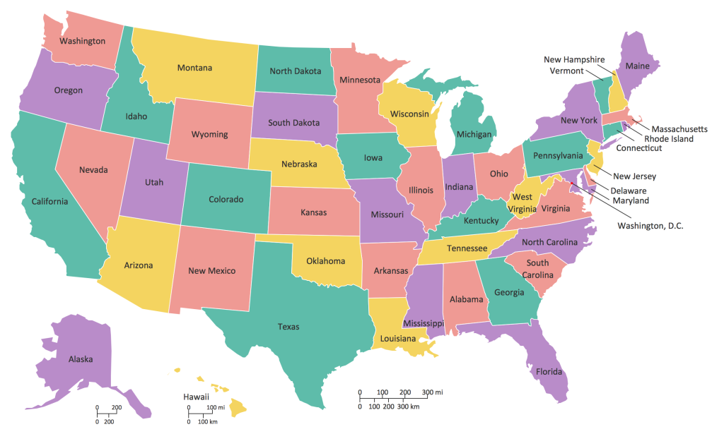
So you think it’s difficult to learn 55 counties? Yes, MD would be easier with only 24 counties. But PA? 67. OH? 88. KY? 120. VA? 133! (plus more than 40 independent cities) — 55 doesn’t seem all that bad now, does it? Besides . . .
Since we first came over the mountains, being a West Virginian has seldom (if ever!) been easy. But . . .
We don’t complain. We do good work.
It’s what we do. It’s who we are.
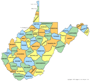
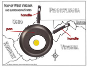
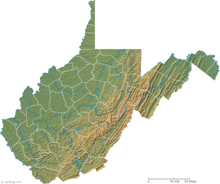
“Use A Map For Help . . .”
. . . because we are NOT going to learn West Virginia counties and county seats in alphabetical order. (Boring!!)
Click here to open a pdf map for help tracing rivers, highways, and railroads. Or use another map of your choosing.
“IT’S QUIZ TIME!”
“Border States” – West Virginia County Quiz
Kentucky – (Tug Fork / Big Sandy River)
The headwaters of the Tug Fork are in McDowell County which then flows northwestward to meet the Levisa Fork at Fort Gay to form the Big Sandy River which, in turn, flows north to the Ohio River. The Tug Fork and Big Sandy form the border between West Virginia and Kentucky.
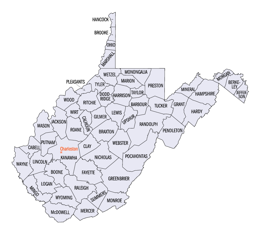
– What West Virginia counties border KY?
– What city or town is the county seat for each one?
– Which county seats, if any, are located along the banks of the Tug Fork/Big Sandy River?
– Through which, if any, flood control dams/reservoirs do these streams flow?
Virginia
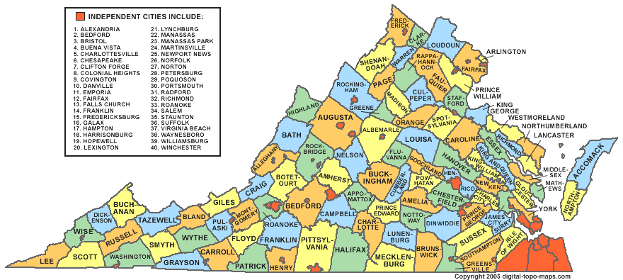
Virginia is sometimes called our “Mother State.” West Virginia has the longest border with it than any other state, and only a very few miles of it is a river or stream. Much of the border follows the Eastern Continental Divide
– Which West Virginia counties border VA?
– What city or town is the county seat for each one?
– Which county seats, if any, are along the border?
Maryland – (North Branch / Potomac River)
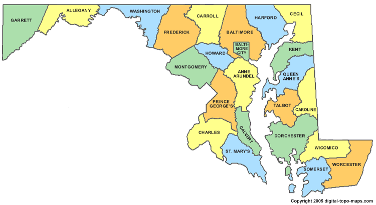
The North Branch of the Potomac River begins at the Fairfax Stone, then flows northeastward. The confluence of the North and South Branches near Green Spring creates the Potomac River, which continues southeastward to Washington, DC and the Chesapeake Bay. The North Branch and the Potomac River form most of the border between West Virginia and Maryland.
– What West Virginia counties border MD?
– What city or town is the county seat for each one?
– Which county seats, if any, are located along the banks of the North Branch or Potomac River?
– Through which, if any, flood control dams/reservoirs do these streams flow?
Bonus: What counties, if any, border MD but are NOT along either stream? What city or town is the county seat for each one?
Pennsylvania
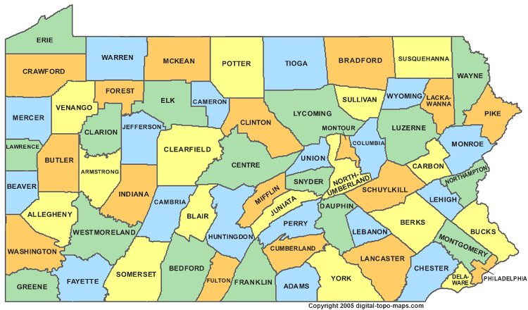
The Mason-Dixon Line forms approximately one half of the border between West Virginia and Pennsylvania.
– Which West Virginia counties border PA?
– What city or town is the county seat for each one?
– Which West Virginia county seats, if any, are along the border?
Ohio – (Ohio River)
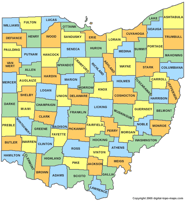
The Ohio River is formed by the confluence of the Allegheny and Monongahela Rivers at Pittsburgh and is the border between West Virginia and Ohio. West Virginia owns the river to the “low watermark” of 1793 on the OH bank.
– What West Virginia counties border Ohio?
– What city or town is the county seat for each one?
– Which county seats, if any, ARE NOT located along the banks of the Ohio River?
– Through which, if any, flood control dams/reservoirs does the Ohio River flow?
“West Virginia Names and Other States” – West Virginia County Quiz
– Which three West Virginia counties have the same name as a State? (One of the county names is just part of the State name.)
– Which four West Virginia counties have the same name as a State Capital? (One of the county names is just part of the Capital name.)
– Which West Virginia county seat has the same name as a State Capital?
– All five states that border West Virginia have a county named Washington. Three of those Washington counties even border West Virginia. But West Virginia does not have a Washington county. Why not?
“West Virginia County Coloring Quiz”
Time for West Virginia Trivia!
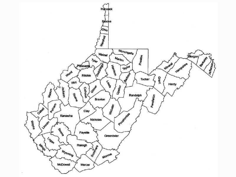
West Virginia’s state colors are Blue and Old Gold. On a map, color the counties in blue or gold/yellow depending on the answer to the trivia questions. [Click here for a map you can use (pdf)] Or just answer them on a piece of paper.
Blue
1 The nation’s first 4H camp took place in this county in June, 1915.
2 The West Virginia State Capitol is located in this county.
3 For the past several years, these 5 counties have reported the highest poultry production in the state.
4 This county raises the most cattle and hay in West Virginia.
5 This county was named after the Marquis de Lafayette, George Washington’s famed French advisor during the Revolutionary War.
6 A town in this county, founded in 1889, was named “Kenova” as an abbreviation for the three states converging on its borders – Kentucky, Ohio and West Virginia.
7 This county is named for a great surveyor, whose first name is “Daniel.”
8 The only exhibition coal mine in the state is in this county.
9 This county celebrates the West Virginia Black Walnut Festival each year.
10 Eleanor Roosevelt took a special interest in an area known as Arthurdale in this county, and it became known as “Eleanor Roosevelt’s New Deal Dream Community.”
11 This county is named for a Native American, famous for helping John Smith.
12 The Golden Delicious apple was found in this county.
13 A Mingo Native American chief is the namesake of this county.
14 This county has the largest man made lake in West Virginia.
15 The West Virginia state 4H conference center is in this county.
16 This is the youngest county in West Virginia.
17 This county is the home of the Mothman Festival.
18 This county’s seat is also known as “The Savings Bond Capital of America.”
19 North Bend State Park is located in this county.
20 The Southeastern United States World Championship Wood Chopping Contest takes place during the annual Wood Chopping Festival in this county.
21 This county includes the geographic center of West Virginia.
22 This county is named for the fifth president of the United States.
23 Canaan Valley Resort State Park, West Virginia’s first ski resort, is in this county.
24 This county shares the name of the President who helped separate West Virginia from Virginia in 1863.
25 This county was named for the Delaware Native American word meaning “Large Plains.”
(Old) Gold
26 This county’s seat claims to host “The Biggest Small Town Fourth of July Celebration” in the United States.
27 The first municipally owned and operated parking building in the United States is in this county’s seat.
28 This county’s seat was named for Elizabeth Beauchamp, an early settler.
29 Since 1988, this county’s seat has enjoyed electricity provided by its own hydroelectric facility.
30 Glenville State College is in this county.
31 The Strawberry Festival is held in this county.
32 A town in this county was named after Eleanor Roosevelt and is the site of the first vocational-technical center in West Virginia.
33 The world’s greatest gas well was drilled in this county in 1884, and produced 100,000,000 cubic feet of gas per day.
34 This county includes the birthplace of General Thomas J “Stonewall” Jackson.
35 This county was named for General Francis __, the “Swamp Fox” of the Revolutionary War.
36 This county’s seat is home to Marshall University. Go Herd!
37 The legend of John Henry takes place in this county.
38 This county includes the site of the first major land battle of the Civil War.
39 This is the second oldest county in the state and was the childhood home of Belle Boyd, a famous Confederate spy.
40 This county’s seat was named for the Grave Creek Mound, believed to be the largest in the world.
41 Named for U.S. Grant, Civil War general and later president of the United States, is this county’s seat.
42 A university, first established in 1867 in this county, was originally named the Agricultural College of West Virginia.
43 The designer of the Great Seal and the Coat of Arms of West Virginia lived in this county.
44 This county’s leading industrial and agricultural products include glass, sand, tomatoes, fruit and rye.
45 Mother’s Day was first observed at Andrews Church in this county on May 10, 1908.
46 West Virginia’s first capital city is in this county.
47 The first steamboat was launched in this county.
48 The West Virginia Bass Festival takes place in this county.
49 The oldest private college in West Virginia, Bethany, is located in this county.
50 The smallest county in West Virginia is this one.
51 This county is home to “Nature’s Air Conditioned City” and the southern end of the West Virginia Turnpike.
[Adapted from “Farm Fun”, published by the West Virginia Department of Agriculture]
“Rivers and Streams”- West Virginia Counties Quiz
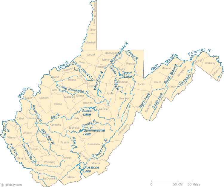
For each River or Stream, answer the following questions:
– Through which West Virginia counties does it flow?
– What city or town is the county seat for each one?
– Which West Virginia county seats, if any, are located along its banks?
– Through which, if any, flood control dams/reservoirs does it flow?
Little Kanawha River
The Little Kanawha River has its headwaters near the community of Kanawha Head in southern Upshur County, and was once navigable for over half its length with a series of (no longer functioning) locks and dams.
Guyandotte River
The Guyandotte River is formed by the confluence of three streams: the Winding Gulf, Stonecoal Creek, and Devils Fork, and meanders its way northward to the Ohio River.
“Great” Kanawha River
The Great Kanawha River begins at the confluence of the New and Gauley Rivers at Gauley Bridge.
Gauley River
The Gauley River has its headwaters in the “Birthplace of Rivers.” Flowing mostly westward, it gathers in a number of other rivers, including the Meadow, Cranberry, Cherry, and Williams, and features dozens of popular whitewater rapids.
New River
The New River is actually one of the world’s oldest rivers. It is one of very few rivers which flow into West Virginia, being formed in NC, then heading north through VA. It has a rich geologic and cultural history.
Greenbrier River
The Greenbrier River is one of the longest in West Virginia and the longest in the Eastern United States without a dam. It is a tributary of the New River and has great recreational value.
Elk River
The Elk River begins in southern Pocahontas County, in the “Birthplace of Rivers” proposed National Monument.
Coal River
There are three Coal Rivers: Coal River, the Big Coal, and the Little Coal. The Big Coal and Little Coal have their headwaters in Raleigh County and wind through Boone County and Lincoln County. Then at Alum Creek, in Kanawha County, the rivers join to form the mainstem Coal River, which flows to the Kanawha River at St. Albans.
Monongahela River
The Monongahela River is formed at the confluence of the West Fork and Tygart Valley Rivers at Fairmont and then flows into PA. West Virginia has one of the greatest concentrations of north flowing rivers in the world, and the “Mon” and most of its tributaries are among them.
West Fork River
The West Fork River is formed near Rock Cave in Upshur County.
Tygart Valley River
The headwaters of the Tygart Valley River are near Snowshoe Ski Resort.
Cheat River
The Cheat is formed by the confluence of Shavers Fork and Black Fork. Black Fork is fed by the Blackwater River and by the Dry, Glady, and Laurel Forks — these are traditionally referred to as the “Five Forks of Cheat.” Because only the hydroelectric Lake Lynn Dam, which creates Lake Lynn (Cheat Lake), impedes its flow, the Cheat watershed, including all five forks, is the largest in the Eastern US without a flood control dam–though the US Army Corps of Engineers has long had plans to create one.
Shavers Fork
Shavers Fork begins at Thorny Flat, highest peak of Cheat Mountain (4,848 ft) and the site of Snowshoe Mountain ski resort. It then flows generally north-northeastwardly through the valley between Cheat Mountain (to the west) and Shavers Mountain (to the east).
Laurel Fork
Laurel Fork rises on a divide separating the watershed of the Cheat River from that of the Greenbrier, and flows in a meandering course between Middle Mountain and Rich Mountain, through the Monongahela National Forest, to its mouth at Dry Fork, approximately four miles northwest of Harman. The last seven miles are characterized by continuous Class 3 rapids.
Blackwater River
The Blackwater River is so named because the tannins of spruce and hemlock trees impart a tea or amber color to its water. Its headwaters are in Canaan Valley State Park, meanders through the Canaan Valley National Wildlife Refuge, falls 62 feet over Blackwater Falls and enters the eight-mile long Blackwater Canyon. The Blackwater River joins the Dry Fork to form the Black Fork which then flows to help form the Cheat River.
Potomac River
The Potomac River is formed at the confluence of the North and South Branches near Green Spring.
South Branch
The South Branch of the Potomac River begins in Highlands County, VA along the Staunton and Parkersburg Turnpike, then flows north along US Rt. 220, enters West Virginia and flows to its meeting with the North Branch.
North Branch
The North Branch of the Potomac River begins at the Fairfax Stone.
Cacapon River
The Cacapon River is formed where the Lost River becomes above ground again, then flows north to enter the Potomac at Great Cacapon.
Lost River
The Lost River is so named because it becomes “lost” when it flows into a cave at “The Sinks.” It reemerges above ground as The Cacapon River.
Shenandoah River
The Shenandoah River flows through the far eastern edge of the Far Eastern Panhandle to join the Potomac at Harpers Ferry.
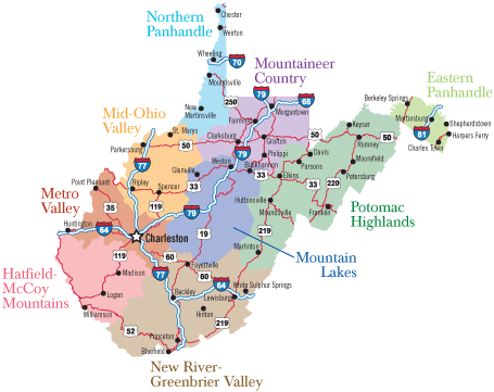
“The Panhandles” – WV County Quiz
In addition to “The Mountain State” and “Almost Heaven,” West Virginia has also been called “The Panhandle State.” Other states also have panhandles, but only West Virginia has two.
Northern Panhandle
Most of the Northern Panhandle lies between OH and PA and is highly industrialized. (Bonus: Why?)
– What West Virginia counties are in the Northern Panhandle? (Because of the similarities in geography, history, topography, and industry, many people define the Northern Panhandle as not just the four most northern counties, but to also include the next one or two counties to the south along the Ohio River)
– What city or town is the county seat for each one?
– Which of the county seats, if any, are located along the banks of the Ohio River?
“Far Eastern” Panhandle
Some people believe West Virginia’s Eastern Panhandle consists of parts or all of eight counties. Others believe it is only made up of the three furthest east – so we’ll call those three the “Far Eastern” Panhandle.
Because of their proximity to the metropolitan areas of the East Coast, two of the counties are becoming more urbanized, while the third retains much of its rural character. (Bonus: Why?)
– What are the three West Virginia counties in the “Far Eastern” Panhandle?
– What city or town is the county seat for each one?
– Which West Virginia county seats, if any, are located along the route of the original B&O railroad?
“Near Eastern” Panhandle
The eight counties of both the “Far Eastern” and “Near Eastern” Panhandles are the only West Virginia counties that are EAST of the Eastern Continental Divide. (A small portion of Monroe County is also on the Eastern side.) The “Near Eastern” panhandle is an area of West Virginia that is mostly agricultural. (Bonus: Why?)
– What five West Virginia counties are in the “Near Eastern” Panhandle?
– What city or town is the county seat for each one?
– Which West Virginia county seats, if any, are located along the South Branch of the Potomac River?
– How about the North Branch?
“Which Match?” – West Virginia County Quiz
Some West Virginia county seats have names similar to the county name. Others can fool you.
Here is list of West Virginia counties and county seats that do, or do not, go together, even though it would “make sense” if they did.
Which match? – For those that do NOT match, which are the correct county seats and the correct counties?
Berkeley
Clay
Fayette
Grant
Lewis
Logan
Morgan
Pleasants
Summers
Taylor
Wayne
Webster
Wood
Berkeley Springs
Clay
Fayetteville
Grantsville
Lewisburg
Logan
Morgantown
Point Pleasant
Summersville
Swift (Kidding!)
Wayne
Webster Springs
Kingwood
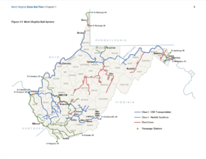
“Railroads” – WV County Quiz
<<More about Current West Virginia Railroads, as well as the History of West Virginia Railroads is on the MH3WV “Transportation” page.>>
1948
Current
Baltimore & Ohio
![]() The Baltimore and Ohio Railroad (now part of CSX) was built to connect the port at Baltimore to the Ohio River and beyond, and to compete with the Erie Canal and the Pennsylvania Railroad and Canals in carrying freight and passengers to the Midwest. The route enters West Virginia at Harpers Ferry and travels to Grafton (partly through MD) and on to Wheeling. Rails to Parkersburg and New Martinsville were laid later. The original route from Fairmont to Moundsville that roughly paralleled US Rt. 250 has been largely abandoned. The route from Clarksburg to Parkersburg is now the North Bend Rail Trail. The route from Clarksburg to New Martinsville remains. AMTRAK’s Capitol Limited passenger train travels in West Virginia between Harpers Ferry and Cumberland MD.
The Baltimore and Ohio Railroad (now part of CSX) was built to connect the port at Baltimore to the Ohio River and beyond, and to compete with the Erie Canal and the Pennsylvania Railroad and Canals in carrying freight and passengers to the Midwest. The route enters West Virginia at Harpers Ferry and travels to Grafton (partly through MD) and on to Wheeling. Rails to Parkersburg and New Martinsville were laid later. The original route from Fairmont to Moundsville that roughly paralleled US Rt. 250 has been largely abandoned. The route from Clarksburg to Parkersburg is now the North Bend Rail Trail. The route from Clarksburg to New Martinsville remains. AMTRAK’s Capitol Limited passenger train travels in West Virginia between Harpers Ferry and Cumberland MD.
– Through what West Virginia counties did the B&O, including its various routes westward from Grafton, pass?
– What city or town is the county seat for each one?
– Which county seats, if any, are located along its path(s)?
Chesapeake & Ohio
![]() The Chesapeake and Ohio (now part of CSX) “mainline” was built after the Civil War, and enters West Virginia near White Sulphur Springs then follows the Greenbrier, New, and Great Kanawha Rivers, and the historic Teays Valley to Huntington and Kenova where it crosses the Big Sandy River into KY. Along the way, it travels through the Great Bend Tunnel of John Henry fame, as well as the New River Gorge, and carries AMTRAK’s Cardinal passenger train. The C&O had/has numerous spur lines across southern WV, and owned The Greenbrier Resort for almost 100 years, until 2009, when it was sold to Jim Justice.
The Chesapeake and Ohio (now part of CSX) “mainline” was built after the Civil War, and enters West Virginia near White Sulphur Springs then follows the Greenbrier, New, and Great Kanawha Rivers, and the historic Teays Valley to Huntington and Kenova where it crosses the Big Sandy River into KY. Along the way, it travels through the Great Bend Tunnel of John Henry fame, as well as the New River Gorge, and carries AMTRAK’s Cardinal passenger train. The C&O had/has numerous spur lines across southern WV, and owned The Greenbrier Resort for almost 100 years, until 2009, when it was sold to Jim Justice.
– Through which West Virginia counties does the C&O mainline pass?
– What city or town is the county seat for each one?
– Which county seats, if any, are located along its path?
Norfolk & Western
![]() The Norfolk and Western (now part of Norfolk Southern) was developed to open the coalfields of western VA and southwest West Virginia, entering West Virginia at the confluence of the East and New Rivers, then north and west to follow the Tug Fork and Big Sandy Rivers to cross the Ohio River. This has now become part of the “Heartland Corridor.” The N&W also had/has numerous branch lines to coal mines.
The Norfolk and Western (now part of Norfolk Southern) was developed to open the coalfields of western VA and southwest West Virginia, entering West Virginia at the confluence of the East and New Rivers, then north and west to follow the Tug Fork and Big Sandy Rivers to cross the Ohio River. This has now become part of the “Heartland Corridor.” The N&W also had/has numerous branch lines to coal mines.
– Through which West Virginia counties does the Heartland Corridor pass?
– What city or town is the county seat for each one?
– Which county seats, if any, are located along its path?
“Tourism Regions” – West Virginia Counties Quiz
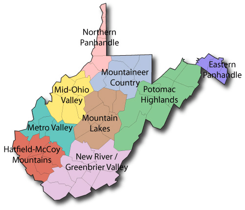
What are the West Virginia counties in each Tourism Region, and what are the county seats?
<<Information and links for Tourism Regions are on the MH3WV “Special Places” page.>>
Northern Panhandle
Mid Ohio Valley
Metro Valley
Hatfield-Mccoy Mountains
New River/Greenbrier Valley
Mountain Lakes
Mountaineer Country
Potomac Highlands
(Far) Eastern Panhandle
“Roads and Highways” – West Virginia Counties Quiz
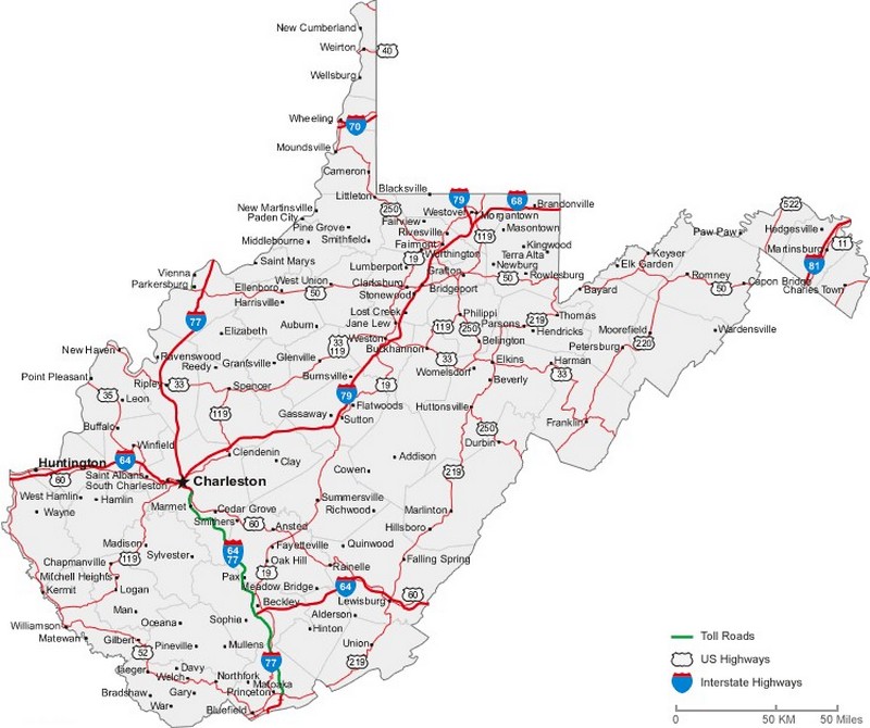
For each Road/Highway, answer the following questions:
– Through which West Virginia counties does it pass?
– What city or town is the county seat for each one?
– Which West Virginia county seats, if any, are located along its path?
Staunton and Parkersburg Turnpike
 The Staunton and Parkersburg Turnpike was one of the earliest routes to travel into and across what is now West Virginia. From Staunton VA in the east, it followed what is now US Rt. 250, then US Rt. 33, and finally WV Rt. 47 to its western terminus in Parkersburg.
US Rt. 50 – Northwestern Turnpike
 US Rt. 50 stretches across the entire United States from coast to coast. In NV, it is often called “The Loneliest Road in America.” But in West Virginia, it is an important connector. It has two sections in West Virginia separated by a short section in MD.
US Rt. 60 – Midland Trail / James River and Kanawha Turnpike
 Like all of the east/west roads and turnpikes (and railroads!) across West Virginia, US Rt. 60 connected the Eastern Seaboard with the Ohio River and beyond.
US Rt. 52
 From Huntington to Bluefield, US Rt. 52 traverses southwest West Virginia. The portion north of Williamson is known as the Tolsia (Tug-Ohio-Levisa-Sandy Improvement Association) Highway; between Williamson and Bluefield, it is being upgraded as the King Coal Expressway.
US Rt. 33
 US Rt. 33 travels east and west across West Virginia between Virginia and the Ohio River.
US Rt. 19
 US Rt. 19 traces its north/south route through the middle of West Virginia, including over the New River Gorge Bridge.
 US Rt. 119 enters northern WV near US Rt. 19, but follows a very different path southward.
Bonus: Where in WV do US Rt. 19 and US Rt. 119 meet and/or cross? (Hint: There are two places.)
US Rt. 219 – Seneca Trail
 US Rt. 219 is also a North/South highway, but east of Rts. 19 and 119.
US Rt. 220
 US Rt. 220 in the “Near Eastern” Panhandle is a north/south route, even though even numbered US highways are normally east/west and odd numbered roads are normally north/south.
US Rt. 250
 US Rt. 250 cuts diagonally across central and northern WV from VA to Wheeling.
Bonus!! Many important historical places are located along US Rt. 250. Name some of them.
WV Rt. 3
 WV Rt. 3 has its western terminus at WV Rt. 10 at West Hamlin then very roughly parallels WV Rt. 10 across southern West Virginia, but its eastern terminus is further east.
WV Rt. 9
 WV Rt. 9 connects the three counties in the “Far Eastern” panhandle.
WV Rt. 10
 WV Rt. 10 connects Huntington and Princeton, carries a great amount of traffic, and is not an easy drive.
WV Rt. 16
 The northern end of WV Rt. 16 is at St. Marys and the southern end is at the southernmost point in WV. Most of its route in the three most southern counties through which it passes is gradually being upgraded as the Coalfields Expressway.
WV Rt. 20
 WV Rt. 20 is one of the longest and “crookedest” roads in West Virginia as it winds its way from near New Martinsville to Bluewell.
Bonus!! WV Rt. 20 passes many interesting places. Name some of them.
WV Rt. 92
 The endpoints of WV Rt. 92 are at Reedsville in the north, and White Sulphur Springs in the south. In between are some very scenic stretches of highway.
“Easy To Confuse” – WV County Quiz
– Charles Town and Charleston are the county seats of which counties? Which county seat is further north?
– Grafton and Middlebourne are the county seats of counties that have very similar names – one has just one more letter than the other. What are the two counties? Which county seat is further north?
– Petersburg and Peterstown. Which one of these is a county seat? Which is further east?
– Williamson and Williamstown. Which one of these is a county seat? Which is further west?
– Charleston, WV and Charleston, SC are often confused by those who don’t live in the area. Sometimes, airlines even send people to the wrong city! An easy way to distinguish them is to call our Charleston “Charlie West” and the other “Charlie South.” Which city has the largest population? And which is further west?
“But Wait! There’s More!” – West Virginia 55 County Quizzes
– Which WV counties have the same name as the surname of a US President? What are the county seats of those counties?
– Which WV county seats have the same name as the surname (or includes the surname) of a US President? What are the counties?
– Which WV counties have names of only one syllable? And what are their county seats?
– Which WV county seats have names of only one syllable? And what are the names of the counties?
– Which WV counties have county seats with names containing the word “New?” Which county seat is further east?
– What other WV counties have county seats with names of two words?
– Which WV county seats have names that end in “-burg,” “-ville,” “-town,” and “-springs?” And what are the names of the counties?
– Two WV county seat names end in “Springs” and both towns have had alternate official names. What are the counties and the alternate names of the towns?
– How did your county, its county seat, your city/town/community, and school get their names?
“ANSWERS” (But only a few) – WV County Quiz
“West Virginia County Coloring Quiz”
1 – Randolph
2 – Kanawha
3 – Hampshire, Pendleton, Grant, Hardy, Mineral
4 – Greenbrier
5 – Fayette
6 – Wayne
7 – Boone
8 – Raleigh
9 – Roane
10 – Preston
11 – Pocahontas
12 – Clay
13 – Logan
14 – Nicholas
15 – Lewis
16 – Mingo
17 – Mason
18 – Wood
19 – Ritchie
20 – Webster
21 – Braxton
22 – Monroe
23 – Tucker
24 – Lincoln
25 – Wyoming
26 – Jackson
27 – McDowell
28 – Wirt
29 – Wetzel
30 – Gilmer
31 – Upshur
32 – Putnam
33 – Tyler
34 – Harrison
35 – Marion
36 – Cabell
37 – Summers
38 – Barbour
39 – Berkeley
40 – Marshall
41 – Calhoun
42 – Monongalia
43 – Doddridge
44 – Morgan
45 – Taylor
46 – Ohio
47 – Jefferson
48 – Pleasants
49 – Brooke
50 – Hancock
51 – Mercer
Maryland – North Branch / Potomac River
“Bonus: What West Virginia counties, if any, border MD but are NOT along either stream [North Branch and Potomac Rivers]? What city or town is the county seat for each one?”
Preston – Kingwood
Northern Panhandle
“The Northern Panhandle lies between OH and PA and is highly industrialized. (Bonus: Why?)”
Some reasons: Early Railroad (B&O) and Road (National Road/US Rt. 40) connections to the east and eventually to the west, the Ohio River for transportation and connection to the industrial hub of Pittsburgh, readily available natural resources (including water, coal, salt, gas, oil), and a productive workforce.
“Far Eastern” Panhandle
“…two of the counties [of the Far Eastern Panhandle] are becoming more urbanized, while the third retains much of its rural character. (Bonus: Why?)
Geographically, Morgan County is further west, and separated from the rest of the Far Eastern Panhandle by hills and ridges with few connecting roads.
“Near Eastern” Panhandle
“The Near Eastern Panhandle is an area of West Virginia that is mostly agricultural. (Bonus: Why?)”
Geographic isolation has contributed, as well as the topography and the preferences of local residents. (Change will likely occur with the completion of Appalachian Corridor H – US Rt. 48 – to the VA state line and eventually to Interstates 81 and 66.)
US Rt. 19 / 119
“Bonus: Where in West Virginia do US Rt. 19 and US Rt. 119 meet and/or cross? (Hint: There are two places.)“
Morgantown and Weston
US Rt. 250
“Bonus: Many important historical places are located along US Rt. 250. Name some of them.”
(N) = Nearby
Staunton and Parkersburg Turnpike Fort Allegheny Camp Bartow Cheat Summit Fort National Radio Astronomy Observatory (N) Cass Scenic Railroad (N) Camp Elkwater Tygart Valley Homesteads Beverly Historic District / Heritage Center Elkins Graceland & Halliehurst Davis and Elkins College Rich Mountain Battlefield (N) Laurel Hill Battlefield Audra State Park (N) Philippi Battlefield Philippi Covered Bridge & Historic District Alderson-Broaddus University Anna Jarvis Birthplace Tygart Lake and Dam (N) Tygart Lake State Park (N) Mothers Day Shrine (N) Grafton Rail Yards (N) West Virginia and Grafton National Cemeteries (N) Fairmont State University Barrackville Covered Bridge Original Route of the B&O Railroad Monongah (N) Farmington Mannington Fish Creek Covered Bridge Roseby’s (Rosbby’s) Rock (N) New Vrindabin – Palace of Gold Grave Creek Mound & Delf Norona Museum Former West Virginia Penitentary West Virginia Independence Hall Wheeling Suspension Bridge
WV Rt. 20
“Bonus!! WV Rt. 20 passes many interesting places. Name some of them.”
(N) = Nearby
West Virginia CCC (Civilian Conservation Corps) Museum
Pringle Tree Park
West Virginia Wesleyan College
Carrollton Covered Bridge
West Virginia Wildlife Center
Holly River State Park
Camp Washington Carver / Clifftop (N)
Babcock State Park (N)
New River Gorge National Park and Preserve
Sandstone Visitor Center
Sandstone Falls
John Henry Park (N)
Bluestone Lake and Dam
Bluestone National Scenic River
Pipestem State Park
Concord University
Bluefield State College (N)
Pinnacle Rock State Park
“Alphabetical List – WV Counties and County Seats”
Barbour
Berkeley
Boone
Braxton
Brooke
Cabell
Calhoun
Clay
Doddridge
Fayette
Gilmer
Grant
Greenbrier
Hampshire
Hancock
Hardy
Harrison
Jackson
Jefferson
Kanawha
Lewis
Lincoln
Logan
McDowell
Marion
Marshall
Mason
Mercer
Mineral
Mingo
Monongalia
Monroe
Morgan
Nicholas
Ohio
Pendleton
Pleasants
Pocahontas
Preston
Putnam
Raleigh
Randolph
Ritchie
Roane
Summers
Taylor
Tucker
Tyler
Upshur
Wayne
Webster
Wetzel
Wirt
Wood
Wyoming
Philippi
Martinsburg
Madison
Sutton
Wellsburg
Huntington
Grantsville
Clay
West Union
Fayetteville
Glenville
Petersburg
Lewisburg
Romney
New Cumberland
Moorefield
Clarksburg
Ripley
Charles Town
Charleston
Weston
Hamlin
Logan
Welch
Fairmont
Moundsville
Point Pleasant
Princeton
Keyser
Williamson
Morgantown
Union
Berkeley Springs
Summersville
Wheeling
Franklin
Saint Marys
Marlinton
Kingwood
Winfield
Beckley
Elkins
Harrisville
Spencer
Hinton
Grafton
Parsons
Middlebourne
Buckhannon
Wayne
Webster Springs
New Martinsville
Elizabeth
Parkersburg
Pineville
“West Virginia County Facts” – WV.GOV
Quick facts for each West Virginia county, including; Year Founded, County Seat, 2005 Population, Cities and Towns, and a link to the US Census’ website for current West Virginia county information.
Visit WV.GOV’s “West Virginia County Information” Website
![]()
WV County Quiz Games
West Virginia County Quiz Games / WV County Quizzes
WV Counties Quiz / West Virginia Counties Quiz
WV County Seats / West Virginia County Seats
West Virginia 55 Counties Quiz Games / WV 55 Counties Quiz
West Virginia County Quiz – WV County Quizzes