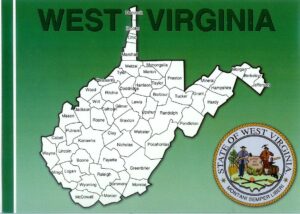
West Virginia Counties
West Virginia Studies
<< Here are the topics on this page; Click to jump/scroll down >>
“West Virginia County Details” – WV.GOV
![]() Quick facts for each West Virginia county, including: Year Founded; County Seat; 2005 Population; Cities and Towns; and a link to the US Census’ website for current West Virginia county information.
Quick facts for each West Virginia county, including: Year Founded; County Seat; 2005 Population; Cities and Towns; and a link to the US Census’ website for current West Virginia county information.
Explore WV.GOV’s “West Virginia County Details” Website
“West Virginia Association of Counties”
“WELCOME to the West Virginia Association of Counties. We are fifty-five reasons why West Virginia is such a wonderful place to live and work, raise our families, and glory in the natural beauty of our hills.
“The resource for West Virginia’s 55 Counties, county government and our elected county officials: Assessors, Circuit Clerks, County Clerks, County Commissioners, Prosecutors, Sheriffs.
“This association provides the tools to assist our elected county officials in making county government work for the benefit of our citizens, promoting the good works from public service, and finding solutions to make West Virginia grow and prosper. Our primary function is coordinating the legislative relations between the counties and the State, influencing legislation at the state capitol in Charleston that affects county government operations and their programs that impact the people.”
Explore “West Virginia Association of Counties” Website
“On-Line Resources by County” – West Virginia Archives and History
 Information presented varies for each county.
“West Virginia Quick Facts” – US Census Bureau
![]() “The U.S. Census Bureau is the leading source of information on the nation’s people, places, and economy, providing data about our country’s population size and growth as well as detailed portraits of the changing characteristics of our communities. The Census Bureau, part of the U.S. Department of Commerce, was created to address language in the Constitution on America’s need to count its population.”
“The U.S. Census Bureau is the leading source of information on the nation’s people, places, and economy, providing data about our country’s population size and growth as well as detailed portraits of the changing characteristics of our communities. The Census Bureau, part of the U.S. Department of Commerce, was created to address language in the Constitution on America’s need to count its population.”
“The QuickFacts data access tool provides users with easy access to basic population, business, and geography statistics for all states and counties, and for cities and towns with more than 5,000 people. This resource is appropriate for use by students.”
Explore US Census’ “West Virginia Quick Facts” Website
“West Virginia State Facts for Students”

![]() “The U.S. Census Bureau takes a census of the population every 10 years, and censuses of economic activity and governments every five years. And every year, the Census Bureau conducts more than 100 other surveys. Data on this page come from the 2010 Census, the American Community Survey, Population Estimates, County Business Patterns.”
“The U.S. Census Bureau takes a census of the population every 10 years, and censuses of economic activity and governments every five years. And every year, the Census Bureau conducts more than 100 other surveys. Data on this page come from the 2010 Census, the American Community Survey, Population Estimates, County Business Patterns.”
Explore US Census’ “West Virginia State Facts for Students” Website
“On the Road in West Virginia: Our 55 Counties”
![]()
 “On the Road in West Virginia: Our 55 Counties is a video documentary of the History and Culture of each West Virginia County in under 10 minutes. Keeping it short, sweet, and entertaining.” (Many Thanks to Wayne Worth and Crew for allowing us to use these videos.)
Explore “On the Road in West Virginia: Our 55 Counties” Website
“West Virginia’s 55 Courthouses – a time lapse film by Alex Wilson”
“Built between 1836 and 2010, West Virginia has 55 county courthouses. Between June and December of 2017 I photographed and filmed them all.” (3:12/2018/Alex Wilson)
—-
WEST VIRGINIA COUNTIES & COUNTY SEATS
(All information is from the West Virginia Blue Book)
———————————————————————————————————————
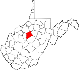
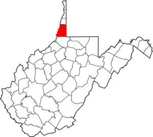
Barbour – Philippi
 “Formed in 1843 from parts of Randolph, Harrison, and Lewis counties; named in honor of Philip Pendleton Barbour, distinguished jurist of Virginia. Leading industries and chief agricultural products: coal, lumber, plastic, buckwheat, dairying, livestock, fruit, poultry, grain.”
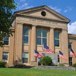
County Courthouse
26 North Main Street
Philippi, WV 26414
Phone: 304-457-4339
Fax: 304-457-5472
Year Founded: 1843
Land Area (sq miles): 341.06
Explore Barbour County Website
Explore US Census’ “Barbour County” Website for more census information and statistics

(6:52/2017-2018/On the Road in West Virginia: Our 55 Counties)
———————————————————————————————————————
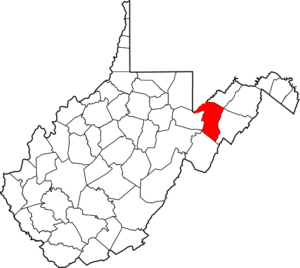
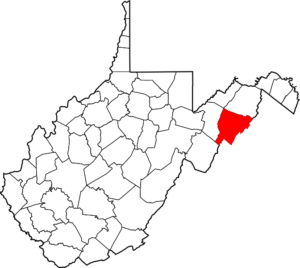
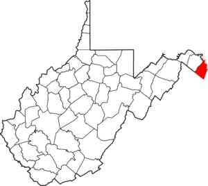
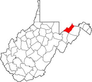
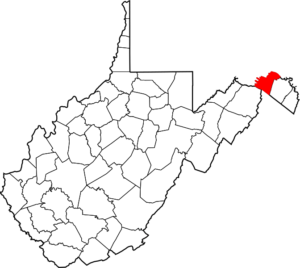
Berkeley – Martinsburg
 “Second oldest county in West Virginia. Created in 1772 from the northern third of Frederick County (Virginia) and named for Norborne Berkeley (Baron de Botetourt), colonial governor of Virginia from 1768 to 1770. At Bunker Hill, in this county, in 1726, Morgan Morgan founded the first permanent settlement of record in western Virginia. In commemoration of this event, the State of West Virginia has erected a monument in Bunker Hill State Park and has placed a marker at the grave of Morgan Morgan, which is in a cemetery near the park. The first Episcopal Church (Christ Church) in what is now West Virginia was erected at Bunker Hill by Morgan Morgan in 1740. Three years later (about 1743), the first Baptist church (Mill Creek Church) was organized at Gerrardstown. Leading industries and chief agricultural products: cement and road materials; General Motors; DuPont; W. Va. Air National Guard; Guardian Fiberglass; Variform Vinyl Siding; Quad Graphics; FedEx; Orgill, Inc.; Ecolab; fruit, vegetables, hay and grain, dairying, livestock, poultry.”
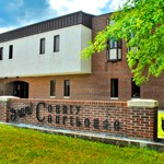
County Courthouse
400 West Stephen Street Suite 201
Martinsburg, WV 25401
Phone: 304-264-1923
Fax: 304-267-5049
Year Founded: 1772
Land Area (sq miles): 321.14
Explore Berkeley County Website
Explore US Census’ “Berkeley County” Website for more census information and statistics

(4:19/2017-2018/On the Road in West Virginia: Our 55 Counties)
———————————————————————————————————————
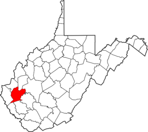
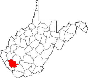
Boone – Madison
 “Formed in 1847 from parts of Kanawha, Cabell, and Logan counties and named for Daniel Boone, noted hunter and explorer, whose home was in the great Kanawha Valley from 1789 to 1795. Leading industries and chief agricultural products: Coal, lumber, natural gas; tobacco, strawberries.”
County Courthouse
206 Court Street #300
Madison, WV 25130
Phone: 304-369-7301
Fax: 304-369-7306
Year Founded: 1847
Land Area (sq miles): 501.54
Explore US Census’ “Boone County” Website for more census information and statistics

(5:38/2017-2018/On the Road in West Virginia: Our 55 Counties)
———————————————————————————————————————
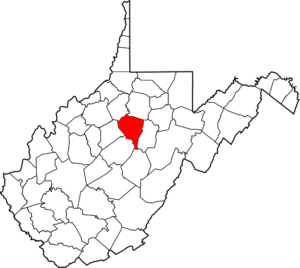
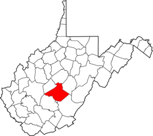
Braxton – Sutton
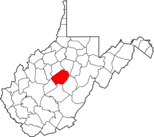 “Formed in 1836 from parts of Lewis, Kanawha, and Nicholas counties and named for Carter Braxton, Virginia statesman and signer of the Declaration of Independence. Important salt works were formerly located at Bulltown and here, in 1772, Captain Bull and his family and friendly Delaware Indians were massacred by frontiersmen. Braxton Game Refuge (6,851.75 acres) is located in this county. Sutton Reservoir, area 1,700 acres; provides camping, boating, fishing (warm water species), flood control impoundment, trout in tail waters of dam. Sportsman’s paradise–northern pike caught (state record 1970). Burnsville Reservoir provides camping, boating, fishing, picnic areas and nature trails. The area is developed for wildlife management by the U.S. Army Corps of Engineers. Leading industries and chief agricultural products: lumber, natural gas; livestock, poultry, dairying, hay and grain.”
County Courthouse
300 Main St
Sutton, WV 26601
Phone: 304-765-7362
Fax: 304-765-2067
Year Founded: 1836
Land Area (sq miles): 510.81
Explore Braxton County Website
Explore US Census’ “Braxton County” Website for more census information and statistics
(5:32/2017-2018/On the Road in West Virginia: Our 55 Counties)
———————————————————————————————————————
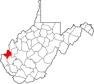
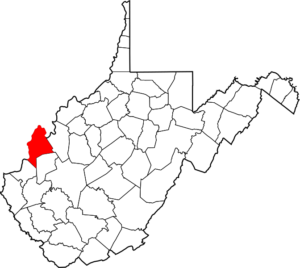
Brooke – Wellsburg
 “Created in 1797 from part of Ohio County and named in honor of Robert Brooke, Governor of Virginia from 1794 to 1796. A monument two miles east of Wellsburg marks the spot where stood the first Grimes Golden apple tree. The first Episcopal Church (St. John’s Church) west of the Allegheny Mountains in what is now West Virginia was erected on the Follansbee-Eldersville Road in this county in 1793. Leading industries and chief agricultural products: Sheet steel and tin plant, sheet metal and tin containers, plastic containers, coal, paper bags and boards, tar and chemicals, electric power, glass and glassware; dairying, fruit.”
County Courthouse
632 Main Street
Wellsburg, WV 26070
Phone: 304-737-3661
Fax: 304-737-4023
Year Founded: 1796
Land Area (sq miles): 89.21
Explore US Census’ “Brooke County” Website for more census information and statistics
(4:57/2017-2018/On the Road in West Virginia: Our 55 Counties)
—-
———————————————————————————————————————
Cabell – Huntington
 “Created in 1809 from Kanawha County and named in honor of William H. Cabell, governor of Virginia from 1805 to 1808. County seat moved from Barboursville to Huntington in 1887. Leading industries and chief agricultural products: glass and glassware, alloys of nickel and its products, railway and mine cars, clothing, steel rails, chemicals, lumber and its products, natural gas; tobacco, dairying, fruit, poultry, sorghum.”
County Courthouse
750 Fifth Avenue Suite 300
Huntington, WV 25701
Phone: 304-526-8634
Fax: 304-526-8648
Year Founded: 1809
Land Area (sq miles): 281.02
Explore US Census’ “Cabell County” Website for more census information and statistics

(7:49/2017/On the Road in West Virginia: Our 55 Counties)
———————————————————————————————————————
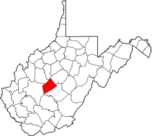
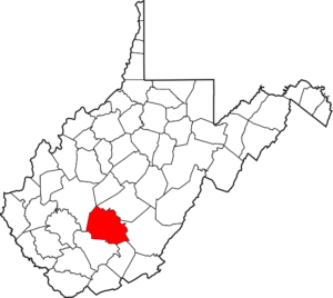
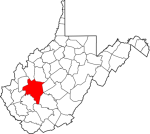
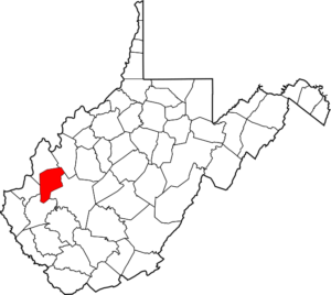
Calhoun – Grantsville
 “Created in 1856 from Gilmer County and named for John C. Calhoun, eminent statesman of South Carolina. In early years the county seat was located in Arnoldsburg, Brooksville and at the mouth of Pine Creek. Leading industries and chief agricultural products: petroleum, natural gas, lumber, RPR Industries; hay and grain, livestock, poultry, dairying.”
County Courthouse
PO Box 230
Grantsville, WV 26147
Phone: 304-354-6725
Fax: 304-354-6447
Year Founded: 1856
Land Area (sq miles): 279.25
Explore Calhoun County Website
Explore US Census’ “Calhoun County” Website for more census information and statistics

(3:58/2017-2018/On the Road in West Virginia: Our 55 Counties)
———————————————————————————————————————
Clay – Clay
 “Formed in 1858 from parts of Braxton, Kanawha, and Nicholas counties and named in honor of Henry Clay, Kentucky statesman. The Golden Delicious Apple originated on Porters Creek, Clay County. Leading industries and chief agricultural products: coal, lumber, natural gas, petroleum; hay and grain, livestock, poultry.”
County Courthouse
246 Main Street PO Box 190
Clay, WV 25043
Phone: 304-587-4249
Fax: 304-587-7329
Year Founded: 1858
Land Area (sq miles): 341.9
Explore US Census’ “Clay County” Website for more census information and statistics

(5:52/2017-2018/On the Road in West Virginia: Our 55 Counties)
———————————————————————————————————————
Doddridge – West Union
 “Created in 1845 from parts of Harrison, Tyler, Ritchie, and Lewis counties and named for Phillip Doddridge, a distinguished statesman of western Virginia who spent the greater part of his life in Brooke County, West Virginia. Home county of J. H. Diss DeBar, who designed the Great Seal and Coat of Arms of West Virginia. Leading industries and chief agricultural products: petroleum, natural gas, lumber; livestock, poultry.”
County Courthouse
101 Church Street, Suite 101
West Union, WV 26456
Phone: 304-873-1373
Fax: 304-873-1840
Year Founded: 1845
Land Area (sq miles): 319.72
Explore Doddridge County Website
Explore US Census’ “Doddridge County” Website for more census information and statistics

(6:41/2017-2018/On the Road in West Virginia: Our 55 Counties)
———————————————————————————————————————
Fayette – Fayetteville
 “Created in 1831 from parts of Greenbrier, Kanawha, Nicholas, and Logan counties and named in honor of the Marquis de LaFayette. First court held at New Haven, near Ansted. New River Gorge Bridge, Canyon Rim, Babcock, and Hawk’s Nest state parks, also Plum Orchard Lake, public fishing area, are located in this county. Leading industries and chief agricultural products: coal, ferro-alloys, lumber; livestock, dairying.”
County Courthouse
100 Court Street PO Box 307
Fayetteville, WV 25840
Phone: 304-574-4290
Fax: 304-574-4255
Year Founded: 1831
Land Area (sq miles): 661.55
Explore Fayette County Website
Explore US Census’ “Fayette County” Website for more census information and statistics

(8:116:52/2017-2018/On the Road in West Virginia: Our 55 Counties)
—-
———————————————————————————————————————
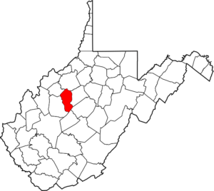
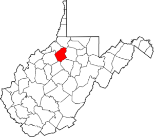
Gilmer – Glenville
 “Formed in 1845 from parts of Lewis and Kanawha counties and named for Thomas Walker Gilmer, governor of Virginia, 1840-1841, later a representative in Congress and Secretary of the Navy in President Tyler’s cabinet. Leading industries and chief agricultural products: petroleum, natural gas, lumber; hay and grain, livestock.”
County Courthouse
10 Howard Street
Glenville, WV 26351
Phone: 304-462-7470
Fax: 304-462-0247
Year Founded: 1845
Land Area (sq miles): 338.5
Explore US Census’ “Gilmer County” Website for more census information and statistics
(4:24/2017-2018/On the Road in West Virginia: Our 55 Counties)
———————————————————————————————————————
Grant – Petersburg
 “Created from Hardy County in 1866 and named for General Ulysses Simpson Grant. The Fairfax Stone, marking the southwestern limit of Maryland, which is determined by the head spring or fountain of the Potomac River, is situated in the extreme western angle of the county. Petersburg Trout Hatchery, Spring Run Trout Hatchery and part of the Monongahela National Forest are located in this county. Leading industries and chief agricultural products: machinery, printing, polymers, electric power, coal, lumber; livestock, hay and grain, poultry, fruit, maple sugar.”
County Courthouse
5 Highland Avenue
Petersburg, WV 26847
Phone: 304-257-4422
Fax: 304-257-9645
Year Founded: 1866
Land Area (sq miles): 477.37
Explore US Census’ “Grant County” Website for more census information and statistics
(5:03/2017-2018/On the Road in West Virginia: Our 55 Counties)
———————————————————————————————————————
Greenbrier – Lewisburg
 “Second largest county in West Virginia. Created in 1778 from parts of Augusta and Botetourt counties (Virginia) and named for the principal river which drains the county. The first permanent settlement was established in 1769 at Frankford (unincorporated). White Sulphur Springs has been a spa since 1778. Now the site of The Greenbrier hotel, it attracts guests from all over the world who come to enjoy The Greenbrier’s magnificent accommodations and sports facilities. Old Stone Church, built in 1796 at Lewisburg, still in use by the congregation, was the first Presbyterian Church erected west of the Allegheny Mountains. Greenbrier State Forest and part of the Monongahela National Forest are located in this county. Leading industries and chief agricultural products: coal, lumber, road materials, resort and convention center, medical school; livestock, hay and grain, poultry, fruit, dairying.”
County Courthouse
912 N Court St
Lewisburg, WV 24901
Phone: 304-647-6689
Fax: 304-647-6694
Year Founded: 1778
Land Area (sq miles): 1,019.57
Explore Greenbrier County Website
Explore US Census’ “Greenbrier County” Website for more census information and statistics

(9:10/2017-2018/On the Road in West Virginia: Our 55 Counties)
———————————————————————————————————————
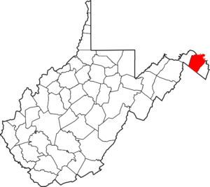
Hampshire – Romney
 “Oldest county in West Virginia. Formed from parts of Frederick and Augusta counties (Virginia), in 1754, and named for the English Shire of the same name. Nathaniel Mountain Game Refuge (8,193.79 acres) and part of the George Washington National Forest are located in this county. On Ice Mountain, 16 miles north of Romney, ice is found along North River throughout the year, even on the hottest summer days. Capon River and the South Branch River provide fishing, canoeing and floating in tributaries of the Potomac River. Leading industries and chief agricultural products: logging and lumber, pulpwood, fruit, hay, cattle and poultry.”
County Courthouse
18 E Main St
Romney, WV 26757
Phone: 304-822-5112
Fax: 304-822-4039
Year Founded: 1754
Land Area (sq miles): 640.25
Explore Hampshire County Website
Explore US Census’ “Hampshire County” Website for more census information and statistics
(4:47/2017-2018/On the Road in West Virginia: Our 55 Counties)
———————————————————————————————————————
Hancock – New Cumberland
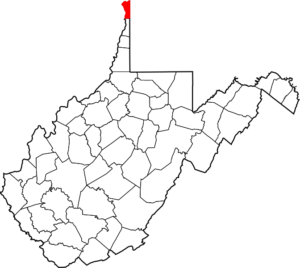 “Smallest county in the state. Created from Brooke County in 1848 and named for John Hancock, first signer of the Declaration of Independence. Cannon balls manufactured at the iron foundry of Peter Tarr, on King’s Creek, were used by Commodore Perry at the Battle of Lake Erie. Tomlinson Run State Park is located in the county. Leading industries and chief agricultural products: iron and steel, including tin plate, chrome plate, hot and cold rolled, galvanized and structural shapes and piling, chinaware, pottery, brick and fire clay, sheet metal, tin products, racetrack, gaming; apples, dairying, livestock. Old Tarr Furnace was the first blast furnace west of the Allegheny Mountains. About two miles away, modern blast furnaces, located in Weirton, are among the largest in the United States. Hancock County is the leading steel-producing county in West Virginia and is the home of ArcelorMittal Steel Company.”
County Courthouse
102 North Court Street PO Box 485
New Cumberland, WV 26047
Phone: 304-564-3311
Fax: 304-564-4059
Year Founded: 1848
Land Area (sq miles): 82.61
Explore Hancock County Website
Explore US Census’ “Hancock County” Website for more census information and statistics

(5:26/2017-2018/On the Road in West Virginia: Our 55 Counties)
—-
———————————————————————————————————————
Hardy – Moorefield
 “Created from Hampshire County in 1786 and named for Samuel Hardy, a distinguished Virginian. Lost River State Park and part of the George Washington National Forest are located in this county. Near Wardensville, Lost River disappears under Sandy Ridge and reappears over four miles away as the headwaters of the Cacapon River. Leading industries and chief agricultural products: lumber, cabinet manufacturing; hay and grain, livestock, dairying, poultry production and poultry processing.”
County Courthouse
204 Washington St
Moorefield, WV 26836
Phone: 304-530-0284
Fax: 304-530-0251
Year Founded: 1786
Land Area (sq miles): 582.31
Explore US Census’ “Hardy County” Website for more census information and statistics

(5:24/2017-2018/On the Road in West Virginia: Our 55 Counties)
———————————————————————————————————————
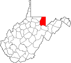
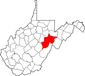
Harrison – Clarksburg
 “Created in 1784 from Monongalia County and named for Benjamin Harrison, distinguished Virginian, who was the father of William Henry Harrison, ninth president of the United States, and the great grandfather of Benjamin Harrison, 23rd president. The first Baptist church (Simpson Creek Baptist Church) west of the Allegheny Mountains in what is now West Virginia was organized at Bridgeport about 1774. West Virginia Industrial Home for Youth is located at Industrial (unincorporated). Leading industries and chief agricultural products: glass and glassware, coal, chemicals, petroleum, natural gas, lumber, chinaware, pottery; livestock, hay and grain, poultry, dairying.”
County Courthouse
301 W Main Street
Clarksburg, WV 26301
Phone: 304-624-8500
Fax: 304-624-8673
Year Founded: 1784
Land Area (sq miles): 416.01
Explore Harrison County Website
Explore US Census’ “Harrison County” Website for more census information and statistics

(9:38/2017/On the Road in West Virginia: Our 55 Counties)
———————————————————————————————————————
Jackson – Ripley
 “Formed in 1831 from parts of Kanawha, Wood, and Mason counties and named for Andrew Jackson, seventh President of the United States. Jesse Hughes, noted Indian fighter, is buried in this county. Leading industries and chief agricultural products: pulpwood, oil and gas, Constellium Aluminum; poultry, livestock, hay and grain, tobacco.”
County Courthouse
PO Box 800
Ripley, WV 25271
Phone: 304-373-2220
Fax: 304-373-0245
Year Founded: 1831
Land Area (sq miles): 464.35
Explore Jackson County Website
Explore US Census’ “Jackson County” Website for more census information and statistics

(8:22/2017-2018/On the Road in West Virginia: Our 55 Counties)
———————————————————————————————————————
Jefferson – Charles Town
 “Formed from Berkeley County in 1801 and named for Thomas Jefferson, author of the Declaration of Independence and third president of the United States. Leading industries and chief agricultural products: cement and road material, clothing, paper, boxboard, lumber, dolomite, fertilizer; fruit, livestock, hay and grain, dairying.”
County Courthouse
119 North George Street P.O. Box 1234
Charles Town, WV 25414
Phone: 304-728-3231
Fax: 304-728-3398
Year Founded: 1801
Land Area (sq miles): 209.64
Explore Jefferson County Website
Explore US Census’ “Jefferson County” Website for more census information and statistics

(6:05/2017-2018/On the Road in West Virginia: Our 55 Counties)
———————————————————————————————————————
Kanawha – Charleston
 “Formed from parts of Greenbrier and Montgomery counties (Virginia) in 1788. Named for the Great Kanawha River, which received its name from the Indian tribe which once dwelt in the territory now embraced within the county. Kanawha State Forest is located in this county. West Virginia State University (formerly West Virginia State College) is located at Institute (unincorporated). Home of the University of Charleston (formerly Morris Harvey College). Leading industries and chief agricultural products: Chemicals and brines, coal, petroleum, natural gas, electric power, lumber, mine machinery and equipment; dairying, hay and grain, fruit, vegetables, livestock. Public recreation areas: Meadowood Park, Tornado; Coonskin Park, Charleston; Shawnee Park, Dunbar; Pioneer Park, East Bank.”
County Courthouse
409 Virginia Street, East
Charleston, WV 25301
Phone: 304-357-0100
Year Founded: 1789
Land Area (sq miles): 901.59
Explore Kanawha County Website
Explore US Census’ “Kanawha County” Website for more census information and statistics

(7:51/2017/On the Road in West Virginia: Our 55 Counties)
—-
———————————————————————————————————————
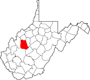
Lewis – Weston
 “Created in 1816 from Harrison County and named for Colonel Charles Lewis, famous soldier and leader among the Virginia Pioneers who was killed at the Battle of Point Pleasant in 1774. Jackson’s Mill, five miles north of Weston, the boyhood home of the famous Confederate General, Thomas J. “Stonewall” Jackson, is the location of the state-owned 4-H camp for boys and girls. The mill is open as a museum during June, July, and August each year. The first Methodist Protestant church in the United States was organized by John Mitchell and David Smith at Old Harmony Church, near Jane Lew, in 1829. Stonewall Jackson Lake, 3,470 acres, is a main recreation and tourism attraction within the county. Leading industries and chief agricultural products: glass and glassware, petroleum, natural gas, lumber; livestock, dairying, hay, grain, poultry, winery.”
County Courthouse
110 Center Ave
Weston, WV 26452
Phone: 304-269-8215
Fax: 304-269-8202
Year Founded: 1816
Land Area (sq miles): 384.9
Explore US Census’ “Lewis County” Website for more census information and statistics
(7:49/2017/On the Road in West Virginia: Our 55 Counties)
———————————————————————————————————————
Lincoln – Hamlin
 “Formed in 1867 from parts of Cabell, Putnam, Kanawha and Boone counties and named in honor of Abraham Lincoln, the 16th president of the United States. Leading industries and chief agricultural products: petroleum, natural gas, lumber; tobacco, corn, potatoes.”
County Courthouse
8000 Court Ave
Hamlin, WV 25523
Phone: 304-824-7900
Fax: 304-824-2444
Year Founded: 1867
Land Area (sq miles): 437.04
Explore Lincoln County Website
Explore US Census’ “Lincoln County” Website for more census information and statistics

(5:52/2017-2018/On the Road in West Virginia: Our 55 Counties)
———————————————————————————————————————
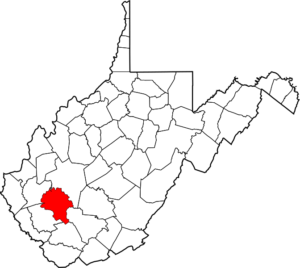
Logan – Logan
 “Formed in 1824 from parts of Giles, Tazewell, Cabell and Kanawha counties (Virginia) and named for Logan, famous Indian chief of the
Mingo tribe. Leading industries and chief agricultural products: coal, lumber, electric power; livestock, dairying, corn, potatoes.”
County Courthouse
300 Stratton Street
Logan, WV 25601
Phone: 304-792-8626
Fax: 304-792-8511
Year Founded: 1824
Land Area (sq miles): 453.74
Explore US Census’ “Logan County” Website for more census information and statistics

(6:35/2017-2018/On the Road in West Virginia: Our 55 Counties)
———————————————————————————————————————
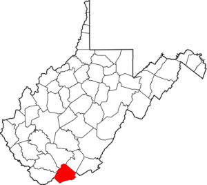
McDowell – Welch
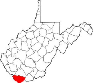 “Created in 1858 from Tazewell County (Virginia) and named in honor of James McDowell, governor of Virginia, 1843-1846. Panther State Park, Anawalt Lake and Berwind Lake Public Hunting and Fishing areas are located in this county. Leading industries and chief agricultural products: large coal-producing county; lumber, natural gas.”
County Courthouse
90 Wyoming St
Welch, WV 24801
Phone: 304-436-8532
Fax: 304-436-8576
Year Founded: 1858
Land Area (sq miles): 533.46
Explore McDowell County Website
Explore US Census’ “McDowell County” Website for more census information and statistics
(7:21/2017/On the Road in West Virginia: Our 55 Counties)
———————————————————————————————————————
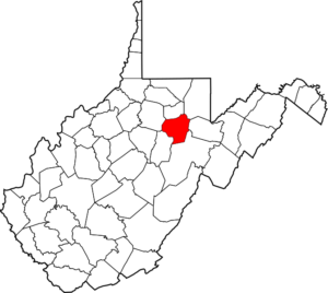
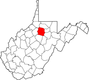
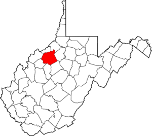
Marion – Fairmont
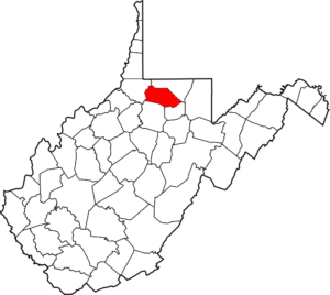 “Created in 1842 from parts of Monongalia and Harrison counties and named in honor of General Francis Marion of Revolutionary War fame, known in history as “The Swamp Fox”. Fairmont was the home of Francis Harrison Pierpont, governor of the Restored Government of Virginia. His outstanding contribution to the formation of West Virginia as the 35th state in 1863 earned him the title of “Father of West Virginia.” Prickett’s Fort State Park, located off W.Va. Route 73, is a tourist attraction in Marion County. Fairmont State University, located in Fairmont, was founded in 1865 as a private school and became a state institution in 1867. Leading industries and chief agricultural products: coal, aluminum sheets, aluminum ventilation louvers and vents, electric power, hydraulic pump and motor parts, computer software application and design, computer hardware manufacturing and other high technology industries, natural gas, telemarketing services; livestock, hay and grain, dairying, poultry.”
County Courthouse
219 Adams Street
Fairmont, WV 26554
Phone: 304-367-5440
Fax: 304-367-5431
Year Founded: 1842
Land Area (sq miles): 308.74
Explore US Census’ “Marion County” Website for more census information and statistics

(8:23/2017/On the Road in West Virginia: Our 55 Counties)
—-
———————————————————————————————————————
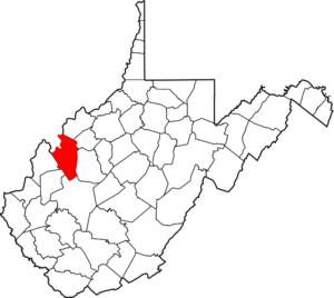
Marshall – Moundsville
 “Formed from Ohio County in 1835 and named for John Marshall, who served as chief justice of the United States Supreme Court for 34 years. Elizabethtown, named as the county seat in the act creating the county, was combined with Moundsville in 1866. Leading industries and chief agricultural products: iron and steel, glass and glassware, chemicals, coal, clothing, natural gas; hay and grain, dairying, fruit, vegetables, sheep.”
County Courthouse
601 7th Street
Moundsville, WV 26041
Phone: 304-843-1550
Fax: 304-845-5891
Background
Year Founded: 1835
Land Area (sq miles): 305.43
Explore Marshall County Website
Explore US Census’ “Marshall County” Website for more census information and statistics

(8:26/2017-2018/On the Road in West Virginia: Our 55 Counties)
———————————————————————————————————————
Mason – Point Pleasant
 “Formed in 1804 from the western portion of Kanawha County and named for George Mason, author of the constitution of Virginia and a member of the convention that framed the U.S. Constitution. This county was a part of the proposed colony of Vandalia, the capital of which was to have been named Point Pleasant. Among the earlier visitors here were Robert D. LaSalle (1669); Pierre Joseph Celoron (1750); and George Washington (1770). Lakin State Hospital was located at Lakin (unincorporated). Leading industries and chief agricultural products: electric power, coal, polyester resins, plastic film, flame retardant plasticizers, synthetic hydraulic fluids and lubricants, jet aircraft lubricants; salt and brine, hay and grain, tobacco, livestock, dairy products, poultry, fruit and vegetables.”
County Courthouse
200 Sixth Street
Point Pleasant, WV 25550
Phone: 304-675-1110
Fax: 304-675-4982
Year Founded: 1804
Land Area (sq miles): 430.75
Explore US Census’ “Mason County” Website for more census information and statistics

(7:18/2017-2018/On the Road in West Virginia: Our 55 Counties)
———————————————————————————————————————
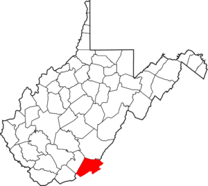
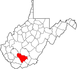
Mercer – Princeton
 “Established in 1837 from parts of Giles and Tazewell counties (Virginia) and named in honor of General Hugh Mercer of Revolutionary War fame. Pinnacle Rock State Park and Camp Creek State Forest are located in this county. Leading industries and chief agricultural products: coal, lumber manufacturing; tourism; hay and grain, dairying, livestock, poultry.”
County Courthouse
1501 W Main St
Princeton, WV 24740
Phone: 304-487-8308
Fax: 304-487-8370
Year Founded: 1837
Land Area (sq miles): 418.99
Explore US Census’ “Mercer County” Website for more census information and statistics
(7:46/2017/On the Road in West Virginia: Our 55 Counties)
———————————————————————————————————————
Mineral – Keyser
 “Created in 1866 from Hampshire County and so named because of the mineral resources found there. Important frontier forts were located in the county during Indian Wars. Monument erected on Mikes Run, near Antioch, at birthplace of Nancy Hanks, mother of Abraham Lincoln. Ashby’s Fort, at Fort Ashby, built in 1755, is the only Indian fort in West Virginia and one of the few east of the Mississippi left standing. Leading industries: paper and national defense weapons. Chief agricultural products: coal, lumber, fruit, hay and grain, livestock, dairying, poultry.”
County Courthouse
150 Armstrong St
Keyser, WV 26726
Phone: 304-788-1562
Fax: 304-788-4109
Year Founded: 1866
Land Area (sq miles): 327.83
Explore Mineral County Website
Explore US Census’ “Mineral County” Website for more census information and statistics

(7:57/2017/On the Road in West Virginia: Our 55 Counties)
———————————————————————————————————————
Mingo – Williamson
 “Youngest county in the state, formed from Logan County in 1895 and named for the Indian tribe of which Logan was chief. Leading industries and chief agricultural products: coal, lumber; livestock, corn, potatoes.”
County Courthouse
75 E 2nd Ave
Williamson, WV 25661
Phone: 304-235 0376
Fax: 304-235-0328
Year Founded: 1895
Land Area (sq miles): 423.11
Explore US Census’ “Mingo County” Website for more census information and statistics

(7:28/2017/On the Road in West Virginia: Our 55 Counties)
—-
———————————————————————————————————————
Monongalia – Morgantown
 “Formed in 1776 from the District of West Augusta (Virginia) and named for the Monongahela River. Part of Coopers Rock State Forest is located in this county.Home of West Virginia University and the Personal Rapid Transit (PRT) System. Leading industries and chief agricultural products: chemicals, coal, glass and glassware, petroleum, lumber; livestock, hay and grain, dairying, fruit, vegetables, poultry.”
County Courthouse
243 High St
Morgantown, WV 26505
Phone: 304-291-7230
Fax: 304-291-7233
Year Founded: 1776
Land Area (sq miles): 360.06
Explore Monongalia County Website
Explore US Census’ “Monongalia County” Website for more census information and statistics
(5:51/2017-2018/On the Road in West Virginia: Our 55 Counties)
———————————————————————————————————————
Monroe – Union
 “Created from Greenbrier County in 1799 and named for James Monroe, fifth President of the United States. Rehoboth Church, near Union, erected in 1786, is the oldest Methodist Church west of the Alleghenies. The edifice is in an almost perfect state of preservation.
Home county of Andrew S. Rowan, of Spanish-American War fame, immortalized in Elbert Hubbard’s classic “A Message to Garcia.” Leading industries and chief agricultural products: lumber, rubber fabricators; tobacco, hay and grain, livestock, poultry, dairying, manufactured stone.”
County Courthouse
216 Main St
Union, WV 24983
Phone: 304-772-3018
Fax: 304-772-5051
Year Founded: 1799
Land Area (sq miles): 472.75
Explore US Census’ “Monroe County” Website for more census information and statistics
(4:33/2017-2018/On the Road in West Virginia: Our 55 Counties)
———————————————————————————————————————
Morgan – Berkeley Springs
 “Formed in 1820 from parts of Hampshire and Berkeley counties and named in honor of General Daniel Morgan, prominent soldier of the Revolutionary War. Cacapon State Park and Timber Ridge Bass Hatchery are located in this county. Leading industries and chief agricultural products: glass sand, tomatoes, fruit, rye.”
County Courthouse
77 Fairfax St
Berkeley Springs, WV 25411
Phone: 304-258-8540
Fax: 304-258-8545
Year Founded: 1820
Land Area (sq miles): 229.07
Explore US Census’ “Morgan County” Website for more census information and statistics
(5:43/2017-2018/On the Road in West Virginia: Our 55 Counties)
———————————————————————————————————————
Nicholas – Summersville
 “Formed in 1818 from parts of Kanawha, Greenbrier and Randolph counties and named for Wilson Cary Nicholas, governor of Virginia, 1814-1816. Carnifex Ferry Battlefield Park and part of Monongahela National Forest are located in this county. The Summersville Reservoir project is located in Nicholas County on the Gauley River. The dam is approximately four miles south-southwest of Summersville, 42 miles east of Charleston and 210 miles west-southwest of Washington, D.C. Length, 13.7 miles; drainage area, 2,723 miles. Leading industries and chief agricultural products: Lumber, coal mining; SMR Engineered Rubber Products, Columbia West Virginia Plywood, Jeld-wen; livestock; river rafting.”
County Courthouse
700 Main St
Summersville, WV 26651
Phone: 304 872-7820
Year Founded: 1818
Land Area (sq miles): 646.82
Explore Nicholas County Website
Explore US Census’ “Nicholas County” Website for more census information and statistics
(6:07/2017-2018/On the Road in West Virginia: Our 55 Counties)
———————————————————————————————————————
Ohio – Wheeling
 “Formed in 1776 from the District of West Augusta* (see note below) (Virginia) and named for the county’s principal river, the Ohio, Indian name for “great river.” One of the first counties in Virginia organized west of the Allegheny Mountains. West Liberty (unincorporated), established in 1787, was the county seat from 1776 to 1797. West Liberty University, a state institution, was established there in 1870, and a continuation of West Liberty Academy, which was founded in 1838. Wheeling Jesuit University, a Jesuit coeducational liberal arts university, was founded in 1954. West Virginia Northern Community College, created in 1972, offers a variety of community-related college courses. Leading industries and chief agricultural products: sheet metal and tin containers and ware, iron and steel, coal, paints, axes and tools, plastic products, stogies, chewing tobacco, meat packing, bakery products, computer ribbons and toner cartridge refiller manufacturing, custom marble tops, international food distribution, custom computers, research and development for advanced software technology, laboratory for new product development, problem solving and applied material research; dairying, fruit, vegetables, hay and grain, poultry.”
* Note: “The District of West Augusta originally included all of the lands of old Virginia from the Blue Ridge west with the southern boundary of that state to the Mississippi River, embracing much of the territory that now comprises the southwestern part of Pennsylvania and most of the states of Ohio, Indiana and Illinois. From the original territory, 18 or more counties in West Virginia and three in Pennsylvania have been carved.”
County Courthouse
1500 Chapline St
Wheeling, WV 26003
Phone: 304-234-3628
Fax: 304-234-3826
Year Founded: 1776
Land Area (sq miles): 105.82
Explore US Census’ “Ohio County” Website for more census information and statistics

(9:39/2017-2018/On the Road in West Virginia: Our 55 Counties)
—-
———————————————————————————————————————
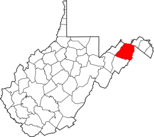
Pendleton – Franklin
 “Created in 1788 from parts of Augusta, Hardy, and Rockingham counties (Virginia) and named for Edmund Pendleton, a distinguished statesman and jurist of Virginia. Two Indian massacres occurred in 1758 at Fort Upper Tract and Fort Seybert, the Indians being led by Kilbuck, a Shawnee chieftain. Spruce Knob, in this county, is the highest point in the state, its elevation being 4,861 feet. Parts of the Monongahela and George Washington National Forests are located in this county. Leading industries and chief agricultural products: lumber; livestock, hay, grain and poultry.”
County Courthouse
100 South Main Street PO Box 187
Franklin, WV 26807
Phone: 304-358-7573
Fax: 304-358-2473
Year Founded: 1788
Land Area (sq miles): 696.05
Explore Pendleton County Website
Explore US Census’ “Pendleton County” Website for more census information and statistics

(5:42/2017-2018/On the Road in West Virginia: Our 55 Counties)
———————————————————————————————————————
Pleasants – Saint Marys
 “Created in 1851 from Wood, Tyler and Ritchie counties and named for James Pleasants, Jr., who represented Virginia in the U.S. Senate and who was its governor, 1822-1825. Leading industries and chief agricultural products: GAP/ENTECH, Cytec, Division of American Cyanamid, Shelly and Sands, Inc., Teikoku USA, Axens North America, Inc., Simonton Building Products, Inc., St. Marys Refining Company, Simex, Pleasants Energy, LLC, Alleghany Power Station, petroleum; Exterran Energy Solutions, LP, Pfizer, St. Marys Correctional Center; poultry, livestock, dairying, hay and grain.”
County Courthouse
301 Court Lane
St Marys, WV 26170
Phone: 304-684-3542
Year Founded: 1851
Land Area (sq miles): 130.1
Explore Pleasants County Website
Explore US Census’ “Pleasants County” Website for more census information and statistics

(6:38/2017/On the Road in West Virginia: Our 55 Counties)
———————————————————————————————————————
Pocahontas – Marlinton
 “Established in 1821 from parts of Bath, Pendleton and Randolph counties (Virginia) and named for Pocahontas, the Indian princess. Eight rivers find their source in Pocahontas County–Cherry, Cranberry, Williams, Gauley, Elk, Tygart Valley, Greenbrier and Shavers Fork of Cheat – thus the county’s nickname, “Birthplace of Rivers.” The site of the Battle of Droop Mountain, in this county, the most extensive Civil War conflict in the state, which occurred on November 6, 1863, was acquired by the state in 1929, and is now Droop Mountain Battlefield State Park. Other historic attractions are: Cass Scenic Railroad, Cass; Pearl S. Buck Birthplace, Hillsboro; Pocahontas County Historical Museum, Marlinton; Locust Creek Covered Bridge, near Hillsboro. Watoga State Park, Seneca State Forest, Calvin W. Price State Forest, the National Radio Astronomy Observatory, Snowshoe Ski Resort, Silver Creek Ski Resort, Cranberry Glades, Beartown State Park, part of the Monongahela National Forest and the Marlinton Trout Hatchery are located in this county. Leading industries and chief agricultural products: lumber, livestock, potatoes, oats, maple sugar.”
County Courthouse
900 10th Ave
Marlinton, WV 24954
Phone: 304-799-6063
Year Founded: 1821
Land Area (sq miles): 940.28
Explore Pocahontas County Website
Explore US Census’ “Pocahontas County” Website for more census information and statistics

(8:14/2017/On the Road in West Virginia: Our 55 Counties)
———————————————————————————————————————
Preston – Kingwood
 “Formed in 1818 from Monongalia County and named in honor of James Patton Preston, governor of Virginia, 1816-1819. Hopemont State Hospital is located at Hopemont (unincorporated). Parts of Coopers Rock State Forest and the Monongahela National Forest are located in this county, and Arthurdale Homestead is located at Arthurdale (unincorporated). Leading industries and chief agricultural products: coal, lumber, cement; buckwheat, hay and grain, poultry, maple sugar.”
County Courthouse
106 W Main St
Kingwood, WV 26537
Phone: 304-329-1805
Fax: 304-329-3192
Year Founded: 1818
Land Area (sq miles): 648.81
Explore Preston County Website
Explore US Census’ “Preston County” Website for more census information and statistics
(7:03/2017-2018/On the Road in West Virginia: Our 55 Counties)
———————————————————————————————————————
Putnam – Winfield
 “Created in 1848 from parts of Kanawha, Mason, and Cabell counties and named in honor of General Israel Putnam, New England soldier and patriot. At Scary Creek, on July 17, 1861, was fought the first engagement of any note of the Civil War in the Kanawha Valley. Leading industries and chief agricultural products: chemicals, electrical power generation, distribution, auto parts manufacturing; tobacco, hay and grain, livestock, dairying.”
County Courthouse
3389 Winfield Rd
Winfield, WV 25213
Phone: 304-586-0230
Year Founded: 1848
Land Area (sq miles): 345.67
Explore US Census’ “Putnam County” Website for more census information and statistics

(5:29/2017-2018/On the Road in West Virginia: Our 55 Counties)
—-
———————————————————————————————————————
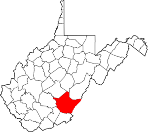
Raleigh – Beckley
 “Created in 1850 from the southern portion of Fayette County and named for Sir Walter Raleigh, the English adventurer and soldier. Grandview National Park, Little Beaver State Park, Lake Stephens Park, Fitzpatrick Park, Winterplace Ski Resort, New River Park, with Beckley Exhibition Coal Mine and Youth Museum located therein, the Tamarack arts and craft center and the Raleigh County 4-H Camp are also located in this county. Leading industries and chief agricultural products: health, tourism, coal and coal-related products, timber, mining equipment, electronic parts, building blocks; cattle, potatoes, peppers, corn, strawberries, show horses–western and English pleasure.”
County Courthouse
215 Main St
Beckley, WV 25801
Phone: 304-255-9132
Fax: 304-255-9166
Year Founded: 1850
Land Area (sq miles): 605.35
Explore Raleigh County Website
Explore US Census’ “Raleigh County” Website for more census information and statistics

(5:35/2017-2018/On the Road in West Virginia: Our 55 Counties)
———————————————————————————————————————
Randolph – Elkins
 “Randolph County was formed from the county of Harrison in 1787 and included all of the present county of Tucker, all of Barbour County east of the Tygart Valley River, all of Upshur County east of the Buckhannon River and a considerable portion of Pocahontas and Webster counties. It lost territory in 1821 when Pocahontas was formed; again in 1843 when Barbour came into existence; in 1851 when it gave up some of its territory to Upshur; in 1856 when 350 square miles were cut off to form Tucker; and another portion was incorporated in Webster County when it was formed in 1860. After all of these losses Randolph still is the largest county in the state. It was named for Edmund Jennings Randolph, governor of Virginia 1786-1788. The first white man who settled in what is now West Virginia built his home on the headwaters of the Monongahela River. In this county occurred the first Indian massacre in the state. From that beginning, the county has been a historical center down to the present. First 4-H Camp in the world was held in this county. Kumbrabow State Forest and part of the Monongahela National Forest are located in this county. Rich Mountain Battlefield is located near Beverly, site of an important battle of the Civil War. Southeast of Huttonsville, on White Mountain (elevation over 4,000 feet), the federal forces maintained the highest fortified camp in the Civil War. Leading industries and chief agricultural products: lumber, furniture, coal, clothing, shoes; potatoes,
hay and grain, livestock, dairying.”
County Courthouse
2 Randolph Avenue PO Box 964
Elkins, WV 26241
Phone: 304-636-4363
Fax: 304-636-2189
Year Founded: 1787
Land Area (sq miles): 1,039.68
Explore Randolph County Website
Explore US Census’ “Randolph County” Website for more census information and statistics

(6:48/2017-2018/On the Road in West Virginia: Our 55 Counties)
———————————————————————————————————————
Ritchie – Harrisville
 “The government offices for Ritchie County are located in Harrisville. The first settler in the vicinity of Harrisville was Lawrence Maley, who arrived there in 1801. The area was originally known then as “Maley’s Settlement.” The town was platted in 1822 and chartered by the State of Virginia as Harrisville and named for Thomas Harris. The first post office was established on July 25, 1833, and was called Solus because a Harrisville post office already existed in the state of Virginia. The name was changed June l, 1847, to Ritchie Court House, Virginia. It was changed again February 14, 1870 to Harrisville, West Virginia. Then on May 11, 1874 it was changed back to Ritchie Court House. The final change was made on August 19, 1895 to Harrisville, in honor of General Thomas M. Harris. General Harris was the nephew of Thomas Harris, for whom the town was originally named. General Harris was also one of the commissioners in the military trial of those accused of plotting the assassination of President Abraham Lincoln. Ritchie County was formed in 1843 from parts of Wood, Harrison, and Lewis counties. When it was formed, it also included land that is now included in Doddridge and Pleasants counties. In the 1860s a small portion of what was Gilmer County was added to Ritchie County. Ritchie County was named in honor of Thomas Ritchie, a distinguished early American journalist. Ritchie was the founder and editor of the Richmond Enquirer in 1804. The paper, under his leadership, became one of the leading newspapers in the country. As editor of the newspaper he championed the cause for the western counties of Virginia. Ritchie’s uncle was Judge Spencer Roane, whom Roane County was named after. There are numerous attractions in the county, including North Bend State Park and Lake and North Bend Rail Trail. This trail has numerous bridges and tunnels and is part of the 5,5OO-mile coast-to-coast American Discovery Trail. Also, W.Va. Route 47 is designated as part of a National Scenic Byway as it closely follows the original route of the historic Staunton-Parkersburg Turnpike. Leading industries and chief agricultural products include: petroleum, natural gas, timber, window manufacturing, automobile carpet manufacturing, aluminum truck bed manufacturing, glass and glassware; livestock, hay and grain.”
County Courthouse
115 E Main St
Harrisville, WV 26362
Phone: 304-643-2164
Fax: 304-643-2906
Year Founded: 1843
Land Area (sq miles): 451.99
Explore Ritchie County Website
Explore US Census’ “Ritchie County” Website for more census information and statistics

(6:01/2017-2018/On the Road in West Virginia: Our 55 Counties)
———————————————————————————————————————
Roane – Spencer
 “Created in 1856 from parts of Kanawha, Jackson, and Gilmer counties and named in honor of Judge Spencer Roane, a distinguished judge of the Supreme Court of Appeals of Virginia, whose wife, Anne, was the daughter of Patrick Henry. Leading industries and chief agricultural products: petroleum, natural gas, lumber and its products; hay and grain, livestock, dairying, poultry.”
County Courthouse
200 Main Street
Spencer, WV 25276
Phone: 304-927-2860
Fax: 304-927-0079
Year Founded: 1856
Land Area (sq miles): 483.56
Explore US Census’ “Roane County” Website for more census information and statistics
(5:31/2017-2018/On the Road in West Virginia: Our 55 Counties)
———————————————————————————————————————
Summers – Hinton
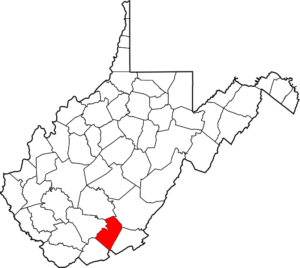 “Formed in 1871 from parts of Monroe, Mercer, Greenbrier, and Fayette counties and named in honor of George W. Summers, a prominent jurist of Kanawha County. Bluestone Lake (1,000 acres), Bluestone State Park, and Pipestem State Park are located in this county. Leading industries and chief agricultural products: lumber; livestock, hay and grain.”
County Courthouse
120 Ballengee Street
Hinton, WV 25951
Phone: 304-466-7100
Fax: 304-466-7128
Year Founded: 1871
Land Area (sq miles): 360.46
Explore Summers County Website
Explore US Census’ “Summers County” Website for more census information and statistics

(6:37/2017-2018/On the Road in West Virginia: Our 55 Counties)
—-
———————————————————————————————————————
Taylor – Grafton
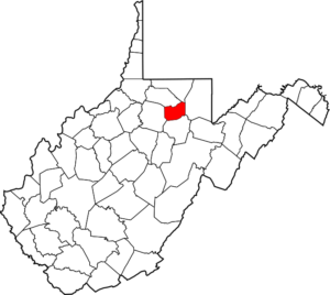 “Created in 1844 from parts of Harrison, Barbour, and Marion counties and named for Senator John Taylor (1750-1824), distinguished soldier and statesman of Carolina County, Virginia. The Mother’s Day Shrine is located in Grafton. Anna Jarvis, founder of Mother’s Day, was born at Webster, a small community just outside Grafton. Tygart Valley River flood control dam, built by the government at a cost of $18.3 million, is located near Grafton. The Pruntytown Correctional Center, formerly the West Virginia Industrial School for Boys, located
at Pruntytown (unincorporated), was established in 1801 under the name of Williamsport, which was the original county seat. The only national cemetery in West Virginia is located in Taylor County. Leading industries and chief agricultural products: Rex-Hide, Inc., Quality Machine Co., Dyna-Tech Adhesives, Inc”
County Courthouse
214 W Main St
Grafton, WV 26354
Phone: 304-265-1401
Fax: 304-265-3016
Year Founded: 1844
Land Area (sq miles): 172.77
Explore US Census’ “Taylor County” Website for more census information and statistics

(6:32/2017-2018/On the Road in West Virginia: Our 55 Counties)
———————————————————————————————————————
Tucker – Parsons
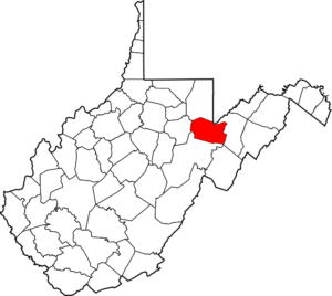 “Formed in 1856 from Randolph County and named for Henry St. George Tucker (1780-1848), an eminent jurist and statesman of Virginia. Blackwater Falls State Park, Canaan Valley State Park, and part of Monongahela National Forest are located in this county. Leading industries and chief agricultural products: Kingsford Charcoal, Hinchcliff Lumber Co., coal, lumber; potatoes, maple sugar, buckwheat, livestock.”
County Courthouse
215 First St
Parsons, WV 26287
Phone: 304-478-2866
Fax: 304-478-2466
Year Founded: 1856
Land Area (sq miles): 418.92
Explore US Census’ “Tucker County” Website for more census information and statistics

(5:20/2017-2018/On the Road in West Virginia: Our 55 Counties)
———————————————————————————————————————
Tyler – Middlebourne
 “Created from Ohio County in 1814 and named in honor of John Tyler, eighth governor of Virginia and father of John Tyler, tenth president of the United States. The world’s greatest gas well, “Big Moses,” producing 100,000,000 cubic feet of gas per day, was drilled in this county in 1894. Leading businesses, industries, and chief agricultural products: glass and glassware; petroleum, natural gas, chemicals; marbles; service industries; artisan crafters; production of dairy, poultry, beef, pork; alpacas; Tyler County Speedway; Oil and Gas Festival.”
County Courthouse
121 Main St
Middlebourne, WV 26149
Phone: 304-758-2102
Fax: 304-758-2126
Year Founded: 1814
Land Area (sq miles): 256.29
Explore US Census’ “Tyler County” Website for more census information and statistics

(6:52/2017-2018/On the Road in West Virginia: Our 55 Counties)
———————————————————————————————————————
Upshur – Buckhannon
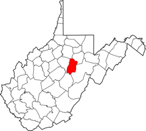 “Formed in 1851 from Randolph, Barbour, and Lewis counties and named for Abel Parker Upshur, distinguished statesman and jurist of Virginia. West Virginia Wildlife Center is located near French Creek (unincorporated). Leading industries and chief agricultural products: lumber, coal, natural gas; clothing; livestock; dairying, strawberries, corn.”
County Courthouse
40 W Main Street
Buckhannon, WV 26201
Phone: 304-472-2370
Fax: 304-472-1673
Year Founded: 1851
Land Area (sq miles): 354.64
Explore US Census’ “Upshur County” Website for more census information and statistics

(5:59/2017-2018/On the Road in West Virginia: Our 55 Counties)
———————————————————————————————————————
Wayne – Wayne
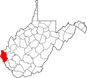 “Formed from Cabell County in 1842 and named in honor of General Anthony Wayne of Revolutionary War fame. Cabwaylingo State Forest, Beech Fork State Park, East Lynn Lake and Beech Fork Lake are located in this county. Leading industries and chief agricultural products: coal, natural gas, lumber, cement and concrete; chemical and petroleum refining, manufacturing, distribution/intermodal facility; hay, grain, tobacco, livestock, dairying, poultry, fruit, vegetables, sorghum.”
County Courthouse
PO Box 248
Wayne, WV 25570
Phone: 304-272-6350
Year Founded: 1842
Land Area (sq miles): 505.98
Explore US Census’ “Wayne County” Website for more census information and statistics

(7:20/2017/On the Road in West Virginia: Our 55 Counties)
—-
———————————————————————————————————————
Webster – Webster Springs
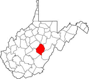 “The last county in West Virginia to be created before the separation from Virginia. Created in 1860 from Nicholas, Braxton, and Randolph counties and named in honor of Daniel Webster, New England orator and statesman. Holly River State Park and part of Monongahela National Forest are located in this county. Leading industries and chief agricultural products: lumber, coal; potatoes, buckwheat, oats, livestock, poultry, honey.”
County Courthouse
2 Court Square
Webster Springs, WV 26288
Phone: 304-847-5780
Fax: 304-847-5780
Year Founded: 1860
Land Area (sq miles): 553.47
Explore Webster County Website
Explore US Census’ “Webster County” Website for more census information and statistics

(5:08/2017-2018/On the Road in West Virginia: Our 55 Counties)
———————————————————————————————————————
Wetzel – New Martinsville
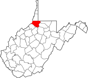 “Created in 1846 from Tyler County and named for Lewis Wetzel, famous frontier character and Indian fighter. Leading industries and chief agricultural products: petroleum, natural gas, glass, glassware, marbles, sand, gravel, cathedral glass; livestock, vegetables, fruit.”
County Courthouse
PO Box 156
New Martinsville, WV 26155
Phone: 304-455-8217
Fax: 304-455-5256
Year Founded: 1846
Land Area (sq miles): 358.06
Explore US Census’ “Wetzel County” Website for more census information and statistics

(5:08/2017-2018/On the Road in West Virginia: Our 55 Counties)
———————————————————————————————————————
Wirt – Elizabeth
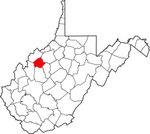 “Formed in 1848 from Wood and Jackson counties and named for William Wirt of Maryland, who gained fame as an author, orator and lawyer in his adopted state of Virginia. Palestine Bass Hatchery is located in this county. Leading industries and chief agricultural products: lumber, petroleum; hay and grain, livestock, poultry, dairying.”
County Courthouse
PO Box 53
Elizabeth, WV 26143
Phone: 304-275-4271
Fax: 304-275-3418
Year Founded: 1848
Land Area (sq miles): 232.51
Explore US Census’ “Wirt County” Website for more census information and statistics

(4:29/2017-2018/On the Road in West Virginia: Our 55 Counties)
———————————————————————————————————————
Wood – Parkersburg
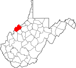 “Formed in 1798 from Harrison County and named in honor of James Wood, governor of Virginia (1796-1799). Blennerhassett Island, in the Ohio River near Parkersburg, is well known because of Harmon Blennerhassett’s participation in Aaron Burr’s conspiracy. Leading industries and chief agricultural products: nylon, shovels, tools, plastic, glass, glassware, pharmaceuticals, porcelain, electrical equipment, oil field equipment, steel and metal products, petroleum; dairying, poultry, livestock, fruit, hay, and grain.”
County Courthouse
One Court Square
Parkersburg, WV 26101
Phone: 304-424-1984
Year Founded: 1798
Land Area (sq miles): 366.26
Explore US Census’ “Wood County” Website for more census information and statistics

(6:10/2017-2018/On the Road in West Virginia: Our 55 Counties)
———————————————————————————————————————
Wyoming – Pineville
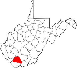 “Created in 1850 from Logan County and named for the Delaware Indian word meaning “large plains”. Leading industries and chief agricultural products: coal, natural gas, lumber; livestock, poultry, hay and grain.”
County Courthouse
24 Cedar Avenue
Pineville, WV 24874
Phone: 304-732-8000
Year Founded: 1850
Land Area (sq miles): 499.45
Explore Wyoming County Website
Explore US Census’ “Wyoming County” Website for more census information and statistics

(5:30/2017-2018/On the Road in West Virginia: Our 55 Counties)
![]()
West Virginia Counties / WV Counties / West Virginia County Seats / WV County Seats